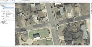
Georeferencing Historical Aerial Photography in ArcGIS 10.1. In this video I take historical imagery from the City of Austin and Georeference it using the built-in Basemap and Georeferencing Toolbar in ArcMap 10.1
http://southwesterngis.blogspot.com/
Original source
28 responses to “Georeferencing Historical Aerial Photography in ArcGIS 10.1”
Right angle me building jaldi kaise bnaye videos bnaiye
Is the video link broken? All I'm seeing is the circular arrow going round and round.
Very nice presentation. . . .
This was very well done! I am not a GIS tech and could follow along easily!
Cheers man this was great tutorial. THUMPS UP
Wonderful tutorial!
This is really helpful. I'm so lost in my GIS class 🙂
This was very helpful, thanks!
I used Camtasia from TechSmith. It is a pretty nice software package.
Also, this is a digression but wanted to know, which software have you used to capture this video?
Thanks! Will keep this in mind the next time I georefrence.
Also I like intersections because over time roads may get winding as cities grow, but the middles are typically the same. Good way to find two points.
Actually the corner of buildings will be less accurate. Objects that extrude from the surface will appear slanted, this is due to the angle of the line of sight between the object and lens. Things close to the surface of the Earth are the best, because their positions will not be distorted. The further from the lens the more distorted the image. Sometimes the building will slant one way in one image and another in a different, introducing even more error. All depends where the lens was.
Is there a reason for not using vertices, like corners of buildings, and using road intersections instead (which are much less accurate)?
Yeah, I bushed over it because I am not a big fan of the scale tool. I prefer to use the "Fit to Display" and then use the pan tool to place the photo in place. The scale tool basically allows you to shrink or expand the image. It is a little clunky to use and can slow you down. What is better is to know the scale the image was before scanning, and then manual type the scale into the display scale, and then do fit to display. So for example if you have a 1:24k image just set the scale to 24k
Great video!! However you only brushed over the scale tool. Do you know how to use this? I am currently trying to georeference two rasters that are very different sizes and cannot get it to work. Thanks!
The power of youtube is better than words sometimes. Great video!
Glad I was able to help!
You Sir are a legend, this video helped me out so much with my assignment for university. THANK YOU SO MUCH MATE!!!!!!
Jpeg should work just fine. ArcMap can support jpeg, sid, tiff, img, and other formats. The georeferencing will generate a jgw file with a jpeg, as opposed to the sdw file generated here.
Hi there. this video is great. What file format does the new imagine need to be in? I tried jpeg but it doesnt accept it. Thanks
Huge help on my assignment where I had to georeference an historic 1933 photo. Thank you!
Thanks
Glad to help
Great video. Thanks, it helped me out tremendously.
Cool voice. Sounds like a radio show.
Wow this was really interesting!! Thanks for putting this together!
Thanks So much for your video. It really helped me .. 🙂