-
Georeferencing Historical Aerial Photography in ArcGIS 10.1
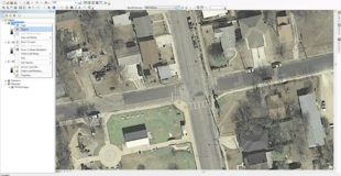
Georeferencing Historical Aerial Photography in ArcGIS 10.1. In this video I take historical imagery from the City of Austin and Georeference it using the built-in Basemap and Georeferencing Toolbar in ArcMap 10.1 http://southwesterngis.blogspot.com/ Original source
-
QML & Javascript: No Browser Required
This session will demonstrate how easy it is to quickly build a fast and powerful native application for any device using QML and JavaScript. QML is an incredibly powerful declarative language that allows you to write lightweight and cross-platform apps in a matter of minutes. Using this JavaScript-like language and the ArcGIS Runtime SDK for…
-
ArcGIS API for JavaScript Part 1: Our First Web Map
In this walkthrough, we will create a very basic web-map using the ArcGIS API for Javascript. For help setting up a development environment in sublime text, you can watch my tutorial video here: http://youtu.be/uOMk8MlE_v4 If you enjoy these videos and would like to support my channel, I would greatly appreciate any assistance through my Patreon…
-
Getting Started with the ArcGIS API for JavaScript
The ArcGIS API for JavaScript is designed to maximize your productivity for building engaging, beautiful web mapping applications. The API combines modern web technology and powerful geospatial capabilities enabling you to create high-performing apps and smarter visualizations of your data. In this webinar, Michael Kelly (Technical Sales Engineer) of Esri Ireland will highlight some key…