-
Georeferencing Historical Aerial Photography in ArcGIS 10.1
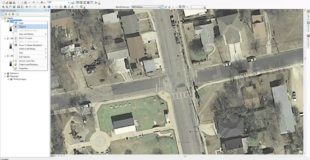
Georeferencing Historical Aerial Photography in ArcGIS 10.1. In this video I take historical imagery from the City of Austin and Georeference it using the built-in Basemap and Georeferencing Toolbar in ArcMap 10.1 http://southwesterngis.blogspot.com/ Original source
-
[MySQL] Tutorial 275 : Connexion avec Qgis
![[MySQL] Tutorial 275 : Connexion avec Qgis](https://d4mations.com/wp-content/uploads/2018/12/1545893264_hqdefault-310x160.jpg)
Connecter Mysql et Qgis. Voici le lien vers le store : https://play.google.com/store/apps/details?id=com.tutorielgeo.mobileapps Voici le lien vers le site internet … Original source
-
QML & Javascript: No Browser Required
This session will demonstrate how easy it is to quickly build a fast and powerful native application for any device using QML and JavaScript. QML is an incredibly powerful declarative language that allows you to write lightweight and cross-platform apps in a matter of minutes. Using this JavaScript-like language and the ArcGIS Runtime SDK for…
-
ArcGIS API for JavaScript Part 1: Our First Web Map
In this walkthrough, we will create a very basic web-map using the ArcGIS API for Javascript. For help setting up a development environment in sublime text, you can watch my tutorial video here: http://youtu.be/uOMk8MlE_v4 If you enjoy these videos and would like to support my channel, I would greatly appreciate any assistance through my Patreon…